|
|||||
| I arrived in Salt Lake City on July 2 at 2:30pm. I hurriedly retrieved my bags and headed for the rental car shuttle. By 3:30 I was northbound on I15 headed for Yellowstone and the second annual pilgrimage to Fairyland Basin deep in the backcountry of the Park. The participants of this trip would be Tim Adkison, Betsy Adkison, Mark Whitham, Jim Collins, and Bob Whidney all from Idaho, Mark Reimers from Omaha Nebraska, Wendy Busch from New York, Matthew, Mary, Jake Young, and Leslie all Yellowstone Park employees and myself. The pressure was off on this trip as I had made the trip the previous summer and knew that barring any unforeseen weather or medical emergency there was no way we would not successfully make the basin again this summer. Tim and Jake, who had successfully made the trip as part of our Summer 2000 group, were also present and we were going to try to get 10 other people into the basin this year. Since the pressure was off, I had decided to prepare a little differently this year for the trip. In the summer of 2000 in addition to my exercise regiment at home, I went to Glacier National Park for some long grueling hikes to acclimatize myself to the elevation difference between Yellowstone and my home in West Virginia. This year I planned on just relaxing in the park until our departure into the backcountry on July 5th. This really seemed work better as I was not nearly as wiped out after this trip as I was in 2000. I do walk 9 miles in the morning 6 days per week at home, however. I arrived at the Old Faithful area on the morning of July 3rd and spent the entire day relaxing on the boardwalks watching the geysers. I achieved a personal record by observing the eruption of Grand geyser 3 times in a 20-hour period. I also saw Beehive, Daisy, Riverside, Sawmill and of course Old Faithful that day. I wandered into the Old Faithful Inn gift shop to see Mathew the Funky Geyserman and when he saw me he said, “I guess you’re here for the same reason I am taking a day off?” “Fairyland Basin” I replied and he shook is head in excited affirmation! Until then I did not realize that he and his girlfriend, Mary would be part of our group. We laughed and talked for a while until the throng of tourists descended upon the gift shop after the eruption of Old Faithful. Then he had to get back to work and I headed out for an ice cream cone. I stayed in the Old Faithful Inn that night and spent the evening preparing for the big Fairyland trip by relaxing on the second floor balcony of the Inn drinking Margaritas and people watching. Life was good. The next day was July 4th and after watching Grand erupt at about 7:30 am, I had breakfast and left the area bound for the Canyon where our group was to meet in the campground and plan our trip the next day. I took my time getting to the Canyon since the others were not expected until later in the day. It was a cloudy day and much cooler than the previous day so there was lots of wildlife out including a Grizzly in the Hayden Valley. I did take a break in my slug mode by hiking down to the brink of the lower falls. Tim and a few of the others arrived late in the afternoon and the backcountry office was closed so we would have to get our permit in the morning before we departed. Everyone except Matthew and Mary (they were to meet us at the trailhead in the morning) eventually showed up. We spent the evening around the campfire talking and eating the best deer steaks I had ever had the pleasure of tasting. Two of Tim’s friends from Idaho, Jim and Bob, provided and cooked the tasty meal. Still in my slug mode, I rented a cabin for the night so I would not have to pack up wet gear for our trip to Fairyland. All of us except Matthew, Mary, Jake, and Leslie, met at Tim’s campsite in the morning of July 5th for a breakfast of scrambled eggs before we headed to the backcountry office at 8:00am to get our permit. After getting our permit we went to the trailhead and waited for the others to arrive. Jake and Leslie came soon after we did and Jake was carrying a big brown packing tube. He informed us that he was drawing a big poster of the highlights of our trip. We all said that it was a great idea and then Jake dryly said, “ Well, if it doesn’t turn out good we can use it to start the fire!!!” It ended up turning out great and I am really glad that Jake decided to use this medium to record the highlights of our trip. Matthew and Mary soon arrived and the first thing that struck me was that all their equipment was brand new, some of it still in the plastic packaging. I pointed out to them that this packaging was extra weight that they did not need to be packing in. Mary’s pack did not fit properly and the jerk in the backpacking store who fitted her should have his neck wrung. She made it work for the trip and eventually made some improvements although it still was not a good fit. I could tell by Mary’s enthusiasm for Fairyland that there was no way she would not successfully make the trip, and I told her so. No one was more fired up than her about Fairyland. Mary did make the mistake of telling me that Matthew told her that her primary goal of the trip was to give me a hard time. I had met Mary the year before after our first trip and when she told me that she was going to be giving me a hard time it was open season as far as I was concerned. We had a real good time getting on each other’s case for the whole trip. We hit the trail at about 9:00 am and quickly broke into two groups, fast and slow. The trail to Moss creek is pretty uneventful with lots of walking in the woods and meadows. There are no real good views. It is a pleasant walk and is slightly uphill all the way with the exception of the first couple of miles through the Hayden Valley. The mosquitoes were very bad in spots and our group hardly took a break until we got to Moss creek. Every time we stopped they would swarm around us in droves. They were so bad that I told Jake that I felt like turning around and going back home because I had been to Fairyland last year and I did not need this crap. Jake thought I was kidding but I was half serious. Jim Collins caught up with us, as well as Eric and Mark, and Jim broke out the deet and all was well with the world again. The fast group arrived at Moss creek in 3 hours flat, a distance of about 7 � miles. The others would arrive about an hour behind us. It is really nice to have enough people to break into two groups as some people like to hike fast and others like to hike at a more leisurely pace. We all took a nice long lunch break at Moss Creek and filtered water, as this is the last place where you can get good water that is not contaminated with hot spring runoff. Tim and I both had our cell phones and the signal at Moss Creek was moderately strong so we each made calls. I called my girlfriend, Sherry to share a little of our trip with her and I also left a message on Buck’s answering machine as he was not home (there’s a surprise). Wendy tried to call Allison but kept getting a wrong number. After our break we all headed down the trail to Orange Rock Springs, which is only about a half mile, further. It is at this point that the 2-mile cross-country trek begins into our campsite at 4B1. We decided that it would be best for all of us to stay together for this leg of the trip. It took a little over two hours to cover the distance. I had waypoints programmed into my GPS from the prior year but Jake insisted that I leave the GPS turned off so we could see if we could find the way by memory and compass, which we did. It was pretty uneventful with the exception of Matthew taking a fall and sustaining a minor ankle sprain, which allowed him to give his tent and sleeping bag to others to carry to lighten his load. He felt much better the next day and was able to hike to Fairyland with no problem. Perhaps he just got tired of carrying all of his new equipment? As soon as we reached our campsite at 4B1 we all went about setting up our tents and gathering wood for the evening’s fire. After all the work was done, I took off down Broad creek to take a much-needed bath. Then I climbed up to a nice spot on the ridge above Broad Creek at Joseph’s Coat Springs, which affords a nice view of the bend of the creek. It is a real nice scene with the many colors of the thermal area and steam coming from the hot springs contrasted against the green of the forested hillside. There is a very nice mud pot there, which was not present last year, giving testament to Yellowstone’s ever changing thermal features. Jake must of thought this was a nice spot to draw his Joseph’s Coat Springs section of his poster as he was already on the ridge working when I arrived. I sat up there with Jake for about an hour relaxing and taking in the early evening view, which was quite relaxing. I made another cell call home from the ridge to share the experience, as the signal was quite strong. I left Jake to finish his drawing and walked back to camp to find some of the others already busy fixing dinner and starting the fire. Mark Reimers had used Tim’s cell phone to check his messages and found that there was a train wreck in Wyoming that he would have had to attend to if they would have been able to get hold of him. Mark works for the railroad and is called out on accidents. He had quite a few very interesting stories to tell and has what I would consider to be a good job if you absolutely have to work. I asked him if he planned on calling in and he informed me that he had no intention doing that. Someone else could handle the emergency. Tim had his usual gourmet dinner although not nearly as elaborate as last year. Most of the rest of us had freeze dried foods or noodles and rice. I tried going extra light this year and brought an Esbit stove since I only had to boil water. It worked out ok but was very slow and I did not have the patience to wait for a roaring boil of the water before dumping it into my freeze-dried food bag. It turned out ok though. We all finished our dinners and sat around the campfire for a while laughing and talking. Mary was very excited and had many questions about the pending trip to Fairyland the next morning. We tried to explain to everyone how the trip was not too bad as long as we were careful and got an early start. It is a very hard hike of 10 miles roundtrip with no trail and lots of deadfall to climb over. Mary seemed very concerned about the final descent into the canyon at the confluence of Broad and Shallow Creeks. I told her it was very steep. She kept pressing as to how steep and I said that it was much like the hike down to the brink of the lower falls of the Yellowstone (this statement would come back to haunt me later). Even though Mary had worked in Yellowstone for two summers she had never done the hike to the Lower Falls so the comparison was lost on her. The mosquitoes became quite bad as the evening wore on and we all retired to our tents before 9:30. We had to get up early in the morning anyway so it was no big deal. I lay in my tent and could see swarms of mosquitoes outside my door and could plainly hear the buzzing. It was very humid that evening and I did not even begin to use my sleeping bag until a light rain awakened me at about midnight. I guess the humidity was the reason the mosquitoes were so bad that night. The next morning, July 6, we arose to a cloudy day and cooler temperatures which, if it did not rain, would be a real blessing to the comfort of our grueling hike to Fairyland. We all had our own version of breakfast. Some cooked and others, such as myself, had granola bars. As we were relaxing around the morning campfire we discussed the options of how to hike to Coffee Pot Hot Springs, the first destination of the hike. There are several ways to get there and it is not hard to find. Jake wanted to try a new route, which took us high off of Broad Creek rather quickly to gain the ridge tops and proceed to Coffee Pot via a forested route. Tim wanted to take a group down Broad Creek abut a mile and then ascend the ridge next to Coffee Pot’s drainage directly into the thermal area. Using this route would almost guarantee a successful navigation to Coffee Pot as long as the correct drainage was ascended. Tim’s GPS waypoints of last year would insure this. Mark, Eric, Matthew, Mary, and myself decided to join Jake and Leslie on this new, untried route. Betsy, Wendy, Bob, and Jim were to accompany Tim downstream to ascend the Coffee Pot drainage as we had done last summer. It was at this time that Mark Reimers informed us that he had developed a very bad blister on his heal the previous day and would be staying back at camp. He had tried all kinds of moleskin and duct tape but nothing seemed to work. So, he probably made the wise choice to stay behind and enjoy the solitude of camp while the rest of us were crashing through the woods scaring all the wildlife away within a 2-mile radius. He did end up seeing a mink come into camp while we were gone. As soon as we finished breakfast, Jake’s group crossed the creek and almost immediately started a slow climb up into the woods away from Broad Creek. Tim’s group was not far behind starting their mile long hike down Broad Creek on their own route. The route that we took through the woods was surprisingly free of deadfall but we did have to cross some minor drainages, which caused descents with a corresponding immediate ascent. If I was to do it over again, I think that Mark Whitham had a good idea in that he wanted to quickly ascend to the ridge directly opposite 4B1 campsite and stay as high as possible winding into the upper stretches of Coffee Pot Hot Springs. However, the route we did take did the trick and we reached Coffee Pot about a half hour before Tim’s group. I think the difference in time was due to the fact that it is a slow process to follow Broad Creek’s drainage for a mile while trying to keep your feet dry. Also, there is a loss of altitude on this route, which must be gained by climbing Coffee Pot’s steep drainage littered with heavy deadfall. While we waited for Tim’s group to arrive, we hiked up into the upper reaches of Coffee Pot Hot Springs, which are more active and very loud. There is a clear view of Mt Washburn from here and the cell signal was as strong as it could get so I made another call to Sherry. I held the phone up so she could hear the how loud the thermal area was. She said that it was not necessary because she could hear it in the background even as we talked. Jake sat at lower Coffee Pot waiting on the others and sketching another piece of his poster as we explored the area. When Tim’s group arrived we allowed them a short break before starting out again cross-country using compass and GPS navigation. We decided that the forest was so thick that it would be best to stay in one group. Betsy took it upon herself to stay in the middle of the pack and try to keep an eye on the leaders as well as those in the rear. It was extremely important not to loose track of anyone. One time Mark took a lower path than the rest of us around a knob and it was not long until he was out of sight. Shouts and whistles brought him back to the group. I think the hike last year was a little easier than this year. Last year we were so intent on tracking a course between the drainages of Broad and Shallow creeks that we immediately gained the top of the ridge and tried to stay high, not falling off of this course in either direction. We were very focused on route finding and maintaining, as we were concerned with finding the difficult single descent point into the canyon. This strategy caused us more ups and downs as we climbed over every high knob of the ridge but I also think that less deadfall was encountered by using this tactic. This year, we tried to avoid the knobs and I think the route was more littered with obstacles. The hike to the confluence of Broad and Shallow Creeks was slow but steady. The sky was completely cloudy and it sprinkled rain on us a couple of times. Finally we reached a point where there was nowhere to go but down. We had no choice but to begin our long descent into Fairyland Basin. Tim and I had been checking our GPS waypoints from the prior year to be sure that we stayed on course. There is only one way which will lead all the way down into the canyon and it is very easy to descend hundreds of feet only to find that you are confronted with a shear cliff and need to turn back. We also knew that we needed to descend to a point which favored the Broad Creek drainage and then finally wind our way around the cliffs to ultimately come down into the Shallow Creek drainage just below Golden Fleece falls. The descent was very steep through the woods but we finally came to the point where we could see down into Broad Creek’s steep canyon and a view of Fairyland far below us. Here the route gets even steeper and more treacherous. We began to wind our way round the side of the hill toward the final waypoint which marked the top of the promontory where a faint trail would lead us down to the base of Golden Fleece falls. As if on cue, the sun broke free of the clouds and the remainder of the day turned out to be beautiful. Tim was in the lead and climbed down to what he thought was the top of the promontory. He yelled up to me and asked me where the final GPS waypoint was and I told him that he was standing on it. He said that he could not see the faint trail and checked his GPS and stated that his waypoint was still a tenth of a mile away. Tim climbed back up and started off to the east toward his waypoint. Mark was ahead of me and I said that this spot looked correct according to my memory. Mark went down to the spot where Tim had been standing and finally found the trail. We yelled for Tim to come back and we all started the final steep descent to Shallow creek. Tim and I later determined that my waypoint was more accurate because I set the co-ordinates last year on our way out of Fairyland when we were on a more true course. Tim had set his at a different point on the way in. This part of the trip is the most dangerous and Tim had brought a rope to string along a section that is especially steep. There was one place where rain has eroded a steep drainage chute. To make things even more dangerous, at the edge of this chute, there is a jumble of deadfall that must be climbed up and over to continue on the faint trail. If anyone of us had slipped and fell at this point we would have slid all the way down to Shallow Creek still a couple of hundred feet below. Certain serious injury would result from such a fall. Before long all of us had safely made our way down to the base of Golden Fleece falls. Some lingered to take in and photograph the falls while others anxiously made their way a quarter mile down Shallow Creek to Fairyland Basin. Fairyland Basin lies mainly on a shield between Broad and Shallow Creeks at the confluence of those creeks. It is protected up stream by Impasse Falls on Broad Creek and Golden Fleece Falls on Shallow Creek. There are many hot springs in the area draining into both of the creeks. Shallow creek is an especially pretty light blue color. There is a very large boulder partly in and beside Broad Creek just below some hot springs. Part of the creek flows under this boulder and if you get into the creek and look into the space between the creek level and the bottom of the boulder you can see a constant spouter shooting up 6 to 12 inches above the water level. Tim discovered this spouter on our first trip to Fairyland in the summer of 2000. Fairyland consists of about fifty travertine cones, most of which are inactive. They are all different sizes in height and width. There is one predominate cone downstream from the confluence as well as other hot springs. I had intended on hiking downstream out of view for some distance, but the hike in took longer than anticipated so I decided to just sit, eat lunch and enjoy the special feeling one gets when surrounded by these unusual formations deep in Yellowstone’s back country far from the maddening crowd. I called home to inform Sherry of our safe arrival and then she called me back to attain another Fairyland milestone… the first cell phone call made into the basin. Mary wanted to call her mother so I gave her my phone. When she got her mother on the phone, she told her how dangerous and hard the trip was and that she hoped we could make it back to camp safely. Then she lost the signal. I told her she better call her mother back so she wouldn’t worry but Mary said she would call when we got back to 4B1, which she did. Others in our group relaxed, waded in the warm water, took photos, ate snacks and generally explored the basin. Matthew and Mary were intent on mapping the location of the cones and Jake started on the main part of his poster. Our time in Fairyland is never long enough, as we have to be concerned with getting back to camp before dark. The climb out of the canyon is steep and a lot of altitude has to be gained back before we would reach more level hiking terrain. This would take time and lots of breaks to catch our breath. Plus, the going would be slow to ensure safety. Jake and Leslie decided that they would be able to catch up to us and elected to remain in the basin long enough for Jake to finish his sketching. Someone, I won’t say who, suspected that Jake and Leslie stayed behind to attain another potential Fairyland first. I said that we were all too dirty and sweaty to entertain any thoughts like that. The hike back to Coffee Pot Hot Springs was long and slow because we were all getting pretty tired. I marked two more GPS waypoints on the way up out of the canyon just in case we ever need them in the future. We stayed higher on the ridge top on the way back and avoided much of the deadfall. When we arrived at lower Coffee Pot, we decided to take a long snack break. Jake is a very capable and experienced hiker and route finder. When we left Fairyland it was agreed that we would just meet he and Leslie back at camp. To our surprise, less than five minutes into our break, Jake and Leslie came strolling in. It had taken them 90 minutes to hike from Fairyland Basin to Coffee Pot Hot Springs, a blazing speed. We all decided to retrace the route that Tim and his group had taken earlier in the morning and descend Coffee Pot’s drainage to Broad Creek and then follow Broad Creek upstream to 4B1 base camp. We stayed high above the drainage but it was just as littered with deadfall as I had remembered from the previous year. We also found bear scat in two different areas of this drainage. We stayed together until we reached Broad Creek so that no one would get lost or hurt. When we reached Broad Creek, camp was still about a mile upstream. But, I was anxious to get back and take a bath to wash off the grime so I set out ahead of the others. After about a quarter mile or so, Bob, Mark and Eric caught up with me and we all went into camp together. The rest of our group was about 20 minutes behind. We all arrived into camp by 8:00 pm tired but happy and excited about our successful trip. Our 10-mile day hike had taken about 12 hours. Although following the creek is an easy way to follow one’s route, walking a streambed is not a fast method of hiking. The evening’s weather was perfect, not a cloud in the sky and the mosquitoes were very minimal due to the lower humidity and cooler temperatures. The stars came out with a vengeance. In spite of our exhaustion, we all fixed our dinners and sat around the evening’s campfire laughing, joking and reliving our trip. At one point Mary stated that the trail down to the brink of the Lower Falls of the Yellowstone must be pretty difficult since I had said that the trail was similar to the descent into Fairyland. Tim then said “you know that trail is paved don’t you Mary?” Mary glared at me and stated that she was going to “get me back”. (I still maintain that the final descent into Fairyland is much like the trail to the brink of the Lower Falls. However, the trail into Fairyland is not paved, steeper, much longer, hard to find, and if you slip in the wrong place you could fall and die. But other than that they are very similar.) The exhaustion of the day’s hike eventually took its toll and one by one we all retired to our tents. Matthew, Mary and I were the last to call it a night at a little after 11:00. I walked out into the dark field to take one last look at the night sky and then crawled into my tent with a satisfied feeling. It was a good day of hiking. The next morning was cool due to the heat loss of the cloudless night. I was the first to get up and immediately started a breakfast fire. There was no hurry to hit the trail and we all took our time fixing breakfast. Bob and Jim had a lot of extra food and were encouraging everyone to eat some of it so that they would not have to carry it out. Jake took advantage of their generosity. Eventually, we all started breaking down our camp and loading our packs for the long hike out. The 2-mile cross-country hike back to the trail at Moss Creek was slow as usual with all the route finding and deadfall to climb over and around. But we eventually made it back to the trail and stopped at Moss Creek near the 4M2 campsite to have lunch. Tim and Wendy made a phone call to Allison with Tim’s phone to share our adventure with her. At about this time I noticed that Mark Whitham was on the small bridge with a young girl who was not part of our group. Several of us went down to talk with her. She was on a day hike in the Canyon area and became lost when she took a wrong turn at a trail sign. The mosquitoes in the area around the sign were so bad that she did not take time to read it carefully. She was 5 miles in the wrong direction and had no idea where she was. It was lucky she ran into us I guess, as she had no food and very little filtered water. We gave her snacks, filtered water for her, gave her deet to fend off the mosquitoes and sent her on her way back down the trail from where she had come. She was a recent high school graduate from Pennsylvania and was traveling around the US alone for the summer before starting college in the fall. I hope she makes it through the summer alive. We decided that since it was a good trail all the way back to the trailhead, it would be ok to break up into groups based upon hiking speeds. Mark Reimers and I took the lead and it was not too long until no one was in sight. Mark and I pounded out a hiking speed, which is faster than I usually go. We passed the previously lost day hiker and she commented to me that if she did not make it back by nightfall to send rangers after her. I told her just to keep following the trail in the same direction and she would have no problem. I quickly left her in my dust comfortable in her safety since 11 others in our group were bringing up the rear. Mark and I arrived at our cars at the trailhead covering the approximately 7-� miles in 2 hours and 9 minutes. I immediately got into the car and was surprised to learn that there was still some ice in my cooler. Unfortunately I only had three drinks. I handed Mark a Pepsi and I opened an orange juice, then I drove back to the Canyon to fill up the cooler with ice and drinks and hurry back to greet the others with cold drinks as they arrived back at the parking lot. Betsy, Jim, Mark Whitham, Eric and Bob arrived at the trailhead 23 minutes behind Mark Reimers and myself. I handed drinks to them and Betsy tried to contact Tim on the walkie-talkie. She eventually got hold of him and based upon the strength of the signal I guessed the remainder of our group was still 2 miles back the trail. About this time the lost day hiker arrived at the trailhead. She was now safe and wanted a ride back to the Canyon area to her car. Jim, Mark and Bob took off with her in their van and I emptied my cooler into Tim’s cooler and told Betsy that I was leaving also to get a shower. After my shower I went into the Canyon Hamilton Store for lunch and met back up with Jim, Mark and Bob. We all had lunch together and they headed off to Idaho and I went to the campground to set up my tent. That was the last I saw of our group for the trip with the exception of running into Wendy in the Lamar Valley looking for wolves. It was a very fun trip this year and I look forward to doing another big hike next year. Tim and I both said that we felt no need to go back to Fairyland again next summer. But you never know, we may be talked into it. Perhaps a big hike into the Thorofare region would be good. What do you think about that, Tim? So, there it is, that's my Fairyland 2001 story and I am sticking to it. Please don’t ask for the GPS waypoints down into the canyon, as I probably won’t give them out for several reasons. I am sure the Park Service would not appreciate me making it any easier for people to attempt this dangerous hike. Also, much of the fun and satisfaction of last year was the challenge of finding that elusive lone route down into the canyon and I would not want to spoil that for anyone else. |
|||||
Click on images to enlarge: |
|||||
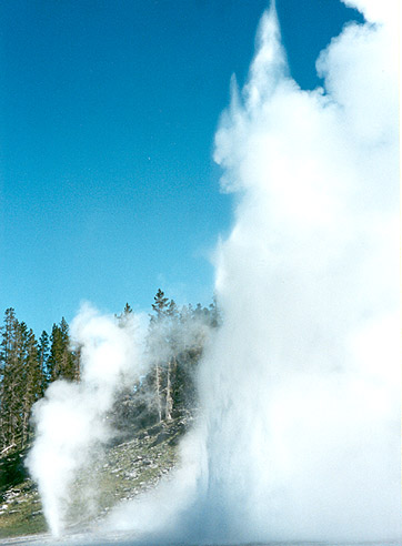
Grand Geyser |
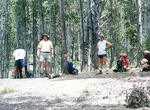
Bob, Jim and Mark taking a break at Moss Creek |
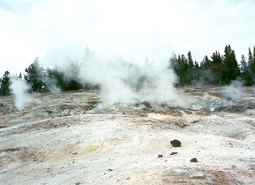
Ridge overlook at Joseph's Coat Springs |
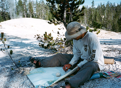
Jake sketching on ridge at Joseph's Coat Springs |
||
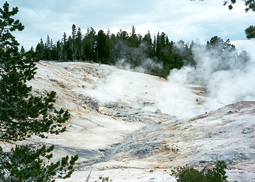
Lower Coffee Pot Hot Springs |
Upper Coffee Pot Hot Springs |
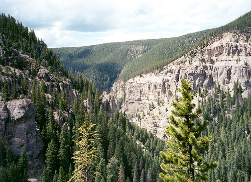
Looking into Broad Creek Canyon |
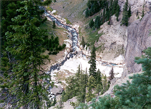
First glimpse of Fairyland |
||
Matthew and Mary at Broad Creek Canyon |
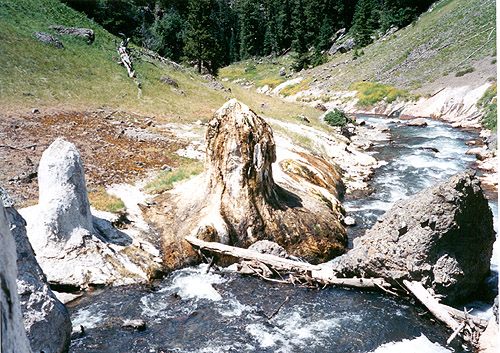
Magic Mushroom |
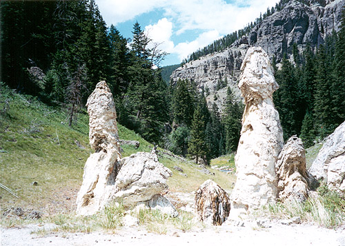
More Cones in Fairyland |
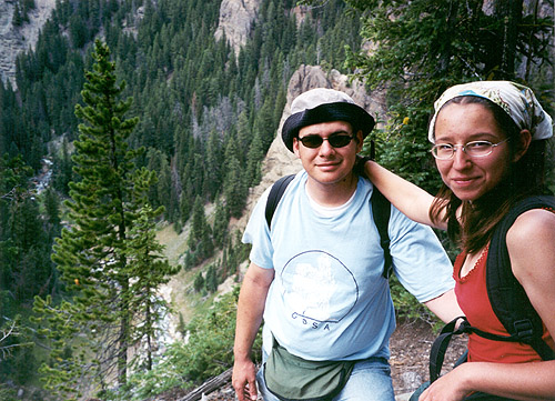
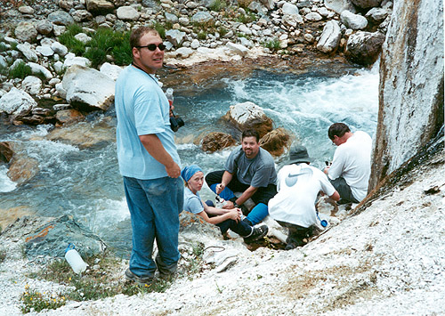
Matthew, Betsy, Tim, Bob and Jim filtering water in Shallow Creek |
||
|
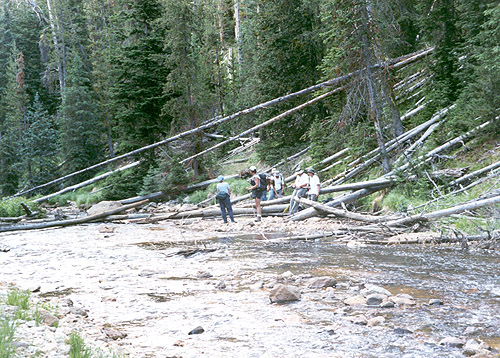
Broad Creek at the bottom of Coffee Pot's drainage. Notice the massive deadfall |
A very colorful spring draining into Broad Creek between Coffee Pot's Drainage and 4B1 Camp |
||||
CLICK HERE for more photos of Fairyland Basin from our Summer 2000 trip |
|||||
|
|||||